

Auction Date:
Auction Location / Nearest City:
Featured items:
- Parcel 1- 188.54 Surveyed acres with farm buildings.
- Parcel 2- 80.98 Surveyed acres.
- Parcel 3- 158.01 Surveyed acres.
- Parcel 4- 82.25 Surveyed acres.
- Parcel 5- 77.79 Surveyed acres.
- Parcel 6- 94.71 Surveyed acres.
view full listing info & Photos
Auction Description:
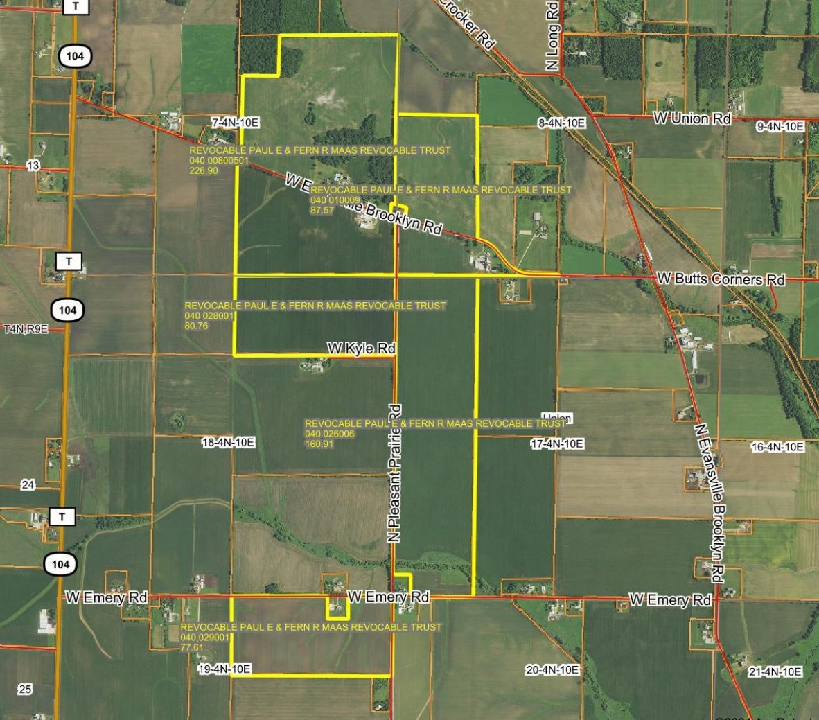
682.28 Surveyed Acres in 6 Parcels – 659 +/- Tillable Acres Union Township Sections 7, 8, 17, 18, & 19 – Rock County, WI
Brooklyn Township Section 11 – Green County, WI
Date/Time: Tuesday November 19 – 1:00 PM
Auction Location: Creekside Place – 102 Maple Street, Evansville, WI 53536.
Directions to Creekside Place: ¼ mile west of The Night Owl on Main Street to Maple Street, south. Luncheon & refreshments will be complementary, beginning with registration at 12:00 Noon.
Auction Brochure: https://www.georgeauction.com/_files/ugd/d71950_aad643a6e2e34219bbfc22c0cd287007.pdf
Directions to Property:
Union Township Parcels – 2 miles north of Evansville, WI on Highway 14 to Butts Corners Road, west (becomes Evansville Brooklyn Road), or 2 miles south of Brooklyn, WI on Highway 104 to Evansville Brooklyn Road, east. Parcels border Evansville Brooklyn Road, Pleasant Prairie Road, & Emery Road. Brooklyn Township Parcel – 1.5 miles south of Brooklyn, WI on Highway 104 to Amidon Road, west.
Note:
Maps & information from FSA & Surety Maps will be available on our website. Parcel information is per AgriData Inc. Surety Maps & FSA. Each parcel will be sold based on the number of surveyed acres, and on a price per acre basis. Parcels will be offered separately through the method of “Buyer’s Choice”, whereas the high bidder can elect any or all parcels for their high bid until all parcels are sold. The parcels will not be offered in their entirety at the conclusion of the auction. Possession will be given at the time of closing & buyer will receive clear title. There is a lease in place for the 2025 crop year.
Terms:
5% buyer’s fee. $10,000.00 Earnest Money per tract, balance due at closing in 45 days or less. Successful bidder required to sign a standard offer to purchase with no contingencies. Announcements day of sale take precedence over printed material. Seller may accept or reject any and all bids.
Parcel 1
188.54 Surveyed acres with farm buildings. 180.58+/- cropland acres, per FSA Maps.
Majority cropland soil types include Pecatonica Silt loam (28.8%), Rotamer Loam (26.8%), St. Charles Silt Loam (15.9%), Plano Silt Loam (7.6%), & Durand Silt Loam (7.6%).
Overall cropland NCCPI weighted average is 73.2.
Union Township, Section 7, Rock County, WI.
Parcel is on north & south side of Evansville Brooklyn Road, and borders Pleasant Prairie Road to the east. This parcel borders parcel 2 and 4.
Farm Buildings: 70’x105’ Morton shop with bi-fold door & concrete floor, 40’x60’ Cleary shed with 40’x70’ lower extension, & 25’x35’ Cleary shed.
Parcel 2
80.98 Surveyed acres. 80.98+/- cropland acres, per FSA Maps.
Majority soil types include Plano Silt Loam (26.5%), Pecatonica Silt Loam (25.7%), & Durand Silt Loam (19.9%).
Overall NCCPI weighted average is 83.6.
Union Township, Section 18, Rock County, WI.
Parcel is on west side of Pleasant Prairie Road, and borders Kile Road to the south. This parcel borders parcel 1.
Parcel 3
158.01 Surveyed acres. 146.62+/- cropland acres, per FSA Maps.
Majority cropland soil types include Durand Silt Loam (33.2%), Pecatonica Silt Loam (30.6%), & Plano Loam (21.3%).
Overall cropland NCCPI weighted average is 87.2.
Union Township, Section 17, Rock County, WI.
Parcel is on east side of Pleasant Prairie Road, and borders Emery Road to the south. This parcel borders parcel 4.
Parcel 4
82.25 Surveyed acres. 80.24+/- cropland acres, per FSA Maps.
Majority soil types include Pecatonica Silt Loam (28.8%), Rotamer Loam (22.7%), & St. Charles Silt Loam (20.6%).
Overall NCCPI weighted average is 72.2.
Union Township, Section 8, Rock County, WI.
Parcel is on north & south side of Evansville Brooklyn Road, and borders Pleasant Prairie Road to the west. This parcel borders parcel 3.
Parcel 5
77.79 Surveyed acres. 76.57+/- cropland acres, per FSA Maps.
Majority soil types include Durand Silt Loam (42.6%), Westville Loam (22.4%), & Kidder Silt Loam (22.3%).
Overall NCCPI weighted average is 77.1.
Union Township, Section 19, Rock County, WI.
Parcel is on west side of Pleasant Prairie Road and borders Emery Road to the north.
Parcel 6
94.71 Surveyed acres. 94.16 cropland acres, per FSA Maps.
Majority soil types include Miami Silt Loam (51.6%) & Stronghurst Silt Loam (11.4%). – Overall NCCPI weighted average is 68.9.
Brooklyn Township, Section 11, Green County, WI. North side of Amidon Road.
102 Maple St, Evansville, WI, USA
Evansville, WI
Auction Location / Nearest City:
Share this on:


LISTING COMPANY